Land Gravity Surveys
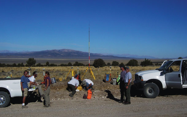
Magee Geophysical Services conduct relative gravity surveys using Scintrex CG-5 (0.001 mGal resolution) and Lacoste and Rhomberg Model-G (0.01 mGal resolution) gravity meters. These instruments record variations in Earth’s gravitational field, at ground level, which are used to detect density contrasts within the Earth. We use geodetic-grade GPS (real-time and post-processed) to achieve centimeter positioning accuracy for all gravity measurements.

Some applications include:
-
Geophysical Prospecting – We design, acquire, process, and interpret gravity data at the regional-, prospect-, and target-scale. The resulting reduced and filtered data can be used for inferring near-surface structure, pseudo-geologic mapping, basin-depth estimation/modelling, and may aid in deposit detection/delineation.
Gravity Networks/Geoid Definition – Gravity measurements are fundamental in determining the figure of the earth and are an important element when determining accurate vertical control used by today’s positioning systems. Our experience with planning, execution, processing and QA/QC for both absolute and relative networks results in high quality datasets with sufficient resolution to map regional geoid undulations, provide reliable gravity datums, determine near-surface vertical gravity gradients, or assist with regional isostatic investigations.
Geothermal Exploration and Groundwater Investigations – We can provide the data necessary to aid in the estimation of the size, shape and depth of basins, interpretation of controlling faults or other subsurface structures and 2D or 3D modelling can be helpful in identifying aquifer/aquitard horizons.
Reservoir Monitoring – Our use of survey-grade GPS coupled with microgravity instruments (0.001 mGal) allow collection of data with sensitivities acceptable for use in time-lapse gravity studies, a technique used in reservoir monitoring.
For more info on our recent work with gravity networks see About Us


Contact us for more information and learn how we may be able to help you with your next project.
Ground Magnetic Surveys
We perform high-resolution (0.001 nT) ground magnetic surveys using Geometrics G-858 Cesium vapor magnetometers which record variations in the Total Magnetic Intensity (TMI) of Earth’s geomagnetic field. Distortions of the field (both in strength and direction) caused by magnetic bodies or objects in the crust make the magnetic method a useful tool in near-surface investigations.
Our ground based systems are arranged to reduce both environmental and methodological noise and constant operation of a base magnetometer allows for the correction of diurnal variations, as well as monitoring for magnetic storms or micropulsations during a survey.

Our roving magnetometers are integrated with differentially-corrected GPS (using WAAS) for real-time navigation and positioning and provide continuous mode surveying with sampling rates up to 10 Hz.
Ground magnetic methods are useful in geothermal, mineral and oil/gas exploration and can be successful in direct detection/delineation of controlling structures, favorable lithotypes, mineral deposits or mineralizing environments. Additionally, ground magnetic data (either stand-alone or combined with gravity data) are a cost-efficient way to implement important constraints on geology and/or other geophysical methods (e.g. seismic, CSAMT, IP, EM, etc.) during the modelling process.

Contact us for more information and learn how we may be able to help you with your next project.
Consulting Services
We provide consulting services including data merges, reprocessing, filtering, and creation of interpretive products for many geophysical methods. Additionally, we provide survey design, QC/QA services, and can provide knowledgeable personnel to train local staff with proper survey procedures.
Contact us for more information and learn how we may be able to help you with your next project.

Other Services
Data Processing – Our data processing is completed daily, in the field, following data acquisition to provide high-quality results in a timely manner.
Gravity data are processed using Geosoft Oasis Montaj software and reduction of data to Complete Bouguer Anomaly (CBA) is carried out using standard procedures. Our use of survey-grade GPS, local slope measurements, 10m- and 30m-USGS digital elevation models (DEM’s), and/or merged proprietary elevation data, allows for the accurate calculation of terrain corrections at the local, intermediate and far-field zones.
Gravity data are presented as color-contoured images of gridded CBA data and, additionally, we offer the standard suite of gridded derivative products including regional/residual separation, vertical derivative, horizontal gradient and analytic signal.
Raw magnetic data are filtered and diurnally corrected using Geometrics Magmap2000 software, then imported into Geosoft Oasis Montaj for further graphical removal of environmental noise. Data are presented as color-contoured images of the gridded Total Magnetic Intensity, and reduced-to-pole transformations can be produced as necessary.

Exploration Grids and GPS Services – We can efficiently and accurately establish exploration grids for other geophysical and geochemical surveys (e.g., soil grids, seismic surveys, electromagnetic surveys, magnetotelluric surveys, etc.). Other GPS services include centimeter accuracy drillhole location surveys and calculation of local site transformations to known datums.
Contact us for more information and learn how we may be able to help you with your next project.
Worldwide Experience
With experience in over 40 countries worldwide, we have the resources and crew to tackle any job, regardless of its geographic location.
| Canada USA Mexico Dominican Republic Belize Jamaica Guatemala Costa Rica St. Lucia Sudan Kenya Tanzania Zimbabwe Zambia Somalia Morocco Congo Malta Oman |
United Arab Emirates Pakistan Kurdistan Region of Iraq Thailand China Papua New Guinea Indonesia Australia Norway United Kingdom France Germany Spain Romania Serbia Kingdom of Saudi Arabia Cypress Colombia |
